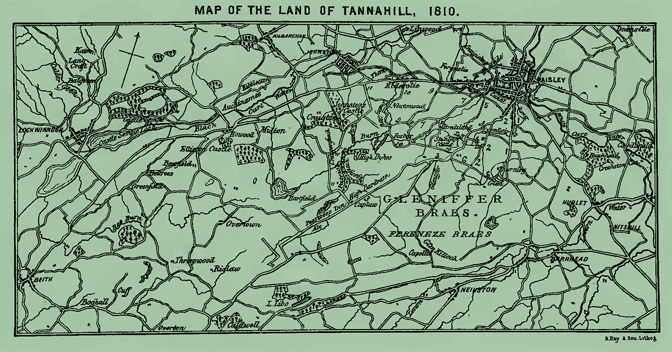
The foregoing map, embracing portions of Renfrewshire and Ayrshire, was prepared for the benefit of visitors visiting the Land of Tannahill, and the classic Braes of Gleniffer. These braes were the ancient forest of Paisley—the hunting ground of the Stewarts, Barons of the Barony of Renfrew, afterwards called Paisley Braes, and now, in one of the sweetest songs of the lyric poet, “The Braes o Gleniffer.”
The map extends east and west a length of 17 miles—from “Cruikston Castle's lamely wa's” in the Abbey Parish of Paisley, to the lands of Boghall in the Parish of Beith, which formerly belonged to the poet's grandfather, and the scene of the song, “Oh I are ye sleepin, Maggie,” and south and north a breadth of 8 miles, from Neilston to Kilbarchan, two villages where the poet had kind and blythe friends whom he often visited.
Visitors, on arriving at the Cross or Market Place of Paisley, should proceed down Saint Mirin Street and up to the head of Causeyside where the road divides,—the one to the left, marked on the map No. 1, in ancient times leading to the furyness (Fereneze), and the other to the right, marked No. 2, leading to the louchlybosyde (Loch Libo side).
I. They may take the Neilston Road on the left, marked No. 1, passing through Neilston Street, Lylesland, Dovealand, Carriagehill, Colinelie, Potterhill, and Thornley, turning to the right, into the Glen Road, marked No. 6, and they will soon arrive at Glenfield, belonging to William Fulton, Esq. of Glen,—one of the loveliest spots a person can visit. A picturesque path leads to the Well,—which the late Mr. Fulton named “Tannahill Well,” after the Poet,—the cascade of Craigie Linn, and the Braes, on the elevated summit of which a magnificent panoramic view of the country, embracing seven counties, will he obtained. This is where the great demonstration proceedings were held on the Poet's Centennial Birth-Day celebration. Proceeding westward along the road, No.6, skirting the Braes of Gleniffer, they will enter the Corsebar Road, marked No. 3, at Nethercraigs, opposite the Stanely Road.
II. Or they may take the Calside Road, marked No. 2, at the head of Causeyside, through Calside Street, past Fairhill, until the division of the road,—the road to the left being a continuation of road No. 2, and the East Corsebar Road to the right, marked No. 3. They may either continue along No. 2, passing the Brodie Public Park and Blackland Mill, where the road divides again,—the one to the left, Braehead Road, being still a continuation of No. 2 (which crosses No. 6), thence to Braehead,—or take the West Blackland Road to the right, marked No. 4, which merges in No. 3 at the Corsebar Toll.
III. Or they may take the East Corsebar Road on the right, marked No. 3, which is better; through that road, passing Corsebar Curling Pond and the Paisley Water Works direct to the Glen of Gleniffer, which they will see marked on the map. This road, passing “the bonnie wee well on the breist o the brae,” leads to the Peesweep Inn, and goes round by the Craigenfeoch Road to the Thorn, marked No. 11, famed for its varying scenery.
IV. Or they may proceed from the Cross along High Street to Broomlands Street, down Maxwelton Street to Maxwelton Road, turn to the left into West Comber Road, marked No. 5, passing the Burgh Asylum, till it merges in No. 3, near the Corsebar Toll.
V. Or they may take the Brediland Road, marked No. 7, leading off Maxwelton Road across “Tannahill Bridge,” passing Loundsdale, into Leitchland Roads, marked Nos. 8 said 9, merging in the Alt Patrick Road, No. 10.
VI. Or they may take the Fulbar or Chain Road, marked No. 9, leading off the Beith road at the west end of Millarston, which merges in No. 10 at Low Bardrain.
VII. Or they may take the Alt Patrick Road, marked No. 10, leading off the Beith road at Sclates, near Elderslie. This road leads to the “Dusky Glen” and “Glenfeoch,” and the other scenery of Alt Patrick Burn,—the scene of the “Soldier's Return.” The road passes Foxber and Stanely Castle “wi its auld turrets” by the Stanely Road, also marked No. 10, merging in No. 3 opposite the west end of the Glen Road, No. 6.
VIII. Or they may take the Craigenfeoch Road, marked No. 11, leading off the Beith road near Thorn, past Craigenfeoch and Craigmuir, merging in No. 3 at the Peesweep Inn. Craigenfeoch,—Gaelic, The Rock of the Raven,—from which a splendid view of Strathgryffe is obtained. “Glenkilloch” will be found on the south side of the Map among Fereneze Braes. “Fairy Woodside,” “Sweet Ferguslie,” and “Bonnie Wood o Craigielee,” nestling on the north-west side of Paisley; and " “Calderglen,” “Balgreen” (“The Echoes o Bowgreen”), and “Langcraft” (which belonged to the Poet's granduncle), will be seen in the far west above Lochwinnoch, and “Overton Braes,” near Beith, where “Dear Will” resided.